Tierra Del Fuego
After our trip in to Patagonia and
Torres del Paine in December '17, my friend Stefano and I still had a few days of New Year's vacation left and decided to venture further south and explore Tierra del Fuego, the island at the southernmost tip of South America separated from the mainland by the
Straits of Magellan.
We took a bus from Puerto Natales in Chile that wound through 10 hours of vast sparsely-populated, windswept steppe to
Ushuaia on the Beagle channel in Argentina, which at 56 degrees South is the southernmost town in the planet and the lanuch-post for trips to Antartica which is just a half-hour flight away.
 |
| Ushuaia and the hills we climbed |
After 8 days camping in the in Torres del Paine, our hostel in Ushuaia felt crowded and touristy with its itinerant population of Americans and Europeans. Despite the excellent wines and steaks we were able to find in the town, we were happy to be away from the town and off camping. We found a three-day circuit that would take us up the tall mountains that towered 1,200 ms (4,000 ft) behind the town.
Day 1: Ushuaia to Lago Esmeralda (12 kms., 8 hours)
A 20 minte cab-ride took us past the edges of town through ramshackle farmlands to a track that led to a fast-flowing stream flowing past some very red peat-bogs. We followed the stream through a track on its right bank cushioned by the the soft, red bogs. A bridge then allowed us to cross the stream and led us into woods. The trail started ascending and a steady climb through tall trees, wet roots for a couple of hours led us to a sudden opening and a view down to a pretty lake formed by a large beaver-dam.
 |
| The Beaver-Dam that built the lake |
 |
| Lake Esmeralda |
From Lake Esmeralda to the Peak
Towering peaks surrounded the lake on three sides. Our guide-book said that there was a trail up to the top of the tallest peak, but we saw no signs. We decided to follow a steep stream that fed the lake. Bush-whacking through tall grasses and tufts of moss we ascended steeply along the stream to barely vegetated rocks. After an hour of climbing, we hit the snow-patches above the tree-line that fed the stream.
We were surrounded by jagged grey peaks fashioned from shingle-piles at very steep angles. It was cold, misty and wet, and it was not even clear where the tallest peak was. We sloughed on up the unstable shingles, slowly slip-sliding our way. A long hour of zig-zagging our way up the steep gravel, we came to some more stable sharp slate; what a relief it was to have stable rock under our feet.
 |
| Slip-Sliding up a mountain of Shingle |
Climbing up, we suddenly realized we were on the ridge as dramatic, steep views of Ushuaia and the Beagle Straights opened up in front of us. Phew, what a slog, but what fantastic views. Mercifully the mist and fog opened up for 10 minutes and we managed to get nice views before the mists closed in again.
 |
| Ushuaia from 1,200 m (4,000 ft) up |
 |
| The Beagle Straights |
The long walk down to our campsite
A long two-hour trek down the shifting shingles took us back to the steep stream and welcome signs of green life again.
 |
| The long walk home |
We stopped on a outcropping with great views of lake Esmeralda for some pictures, gorp and water.
 |
| Luckily leads to this |
 |
| Steep! |
 |
| Mountains of Shingles |
 |
| The peaks we'd left quickly for shrouded in mist |
 |
| Ah, finally the mists leave us |
Another hour of walking over soft moss-tufts and grasses took us to back to lake Esmeralda. Another hour through woods finally got us to the flatlands and the fast-flowing clear stream we'd crossed in the morning.
The magical campsite at a bend in the stream
We crossed the stream and found a pretty meadow at a bend in the stream. What a wonderful camp-site: a soft green meadow; a limpid fast-flowing stream on two sides; mountains all around.
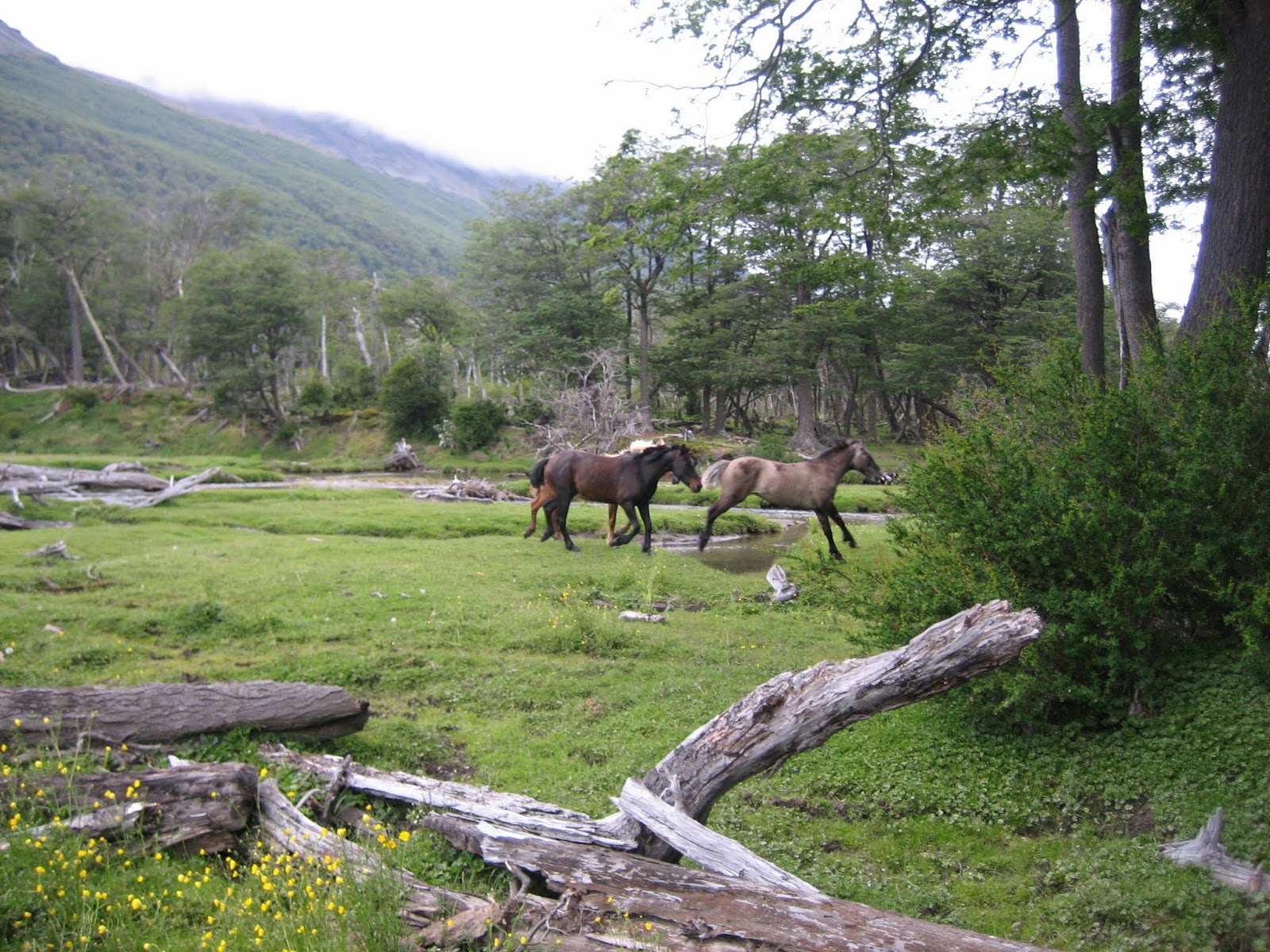
Wild Horses
We set up camp and started making dinner when we heard thundering sounds punctuating the rustling-sounds of the ever-present winds. Startled, we looked up and saw a herd of colorful horses galloping straight toward us. Ducking behind trees we realized they hadn't seen us; they stopped when they noticed the intruders in what must have been one of their favorite grazing spots. After some curious looks the eight horses -colorfully brown, white and black, went about their business of munching on the rich, moist grasses. It was clear that the wild-horses were very used to people.
 |
| All |
 |
| the pretty |
 |
| horses |
What a tiring but lovely day: a tranquil lake; soaring-peaks; snow, mist and gusts; stupendous views; idyllic camping and wild horses!
Day 2: Lago Esmeralda to Lago Caminado (12 kms. 7 hrs)
Day 2 started with a long walk through 10 kms of very wet woods where we were constantly navigating through wet sticky mud and trying to discover a root or rock to step on without slipping. It was slow going and when, after four tedious hours, the trail started heading uphill to dryer terrain, we were relieved despite ascending with 35 lb packs.
A half hour ascent took us to an opening and a view of the pass we'd have to ascend the next day. A side route promised us Lake Caminada. A half hour of ascending and curving through steep, green daisy-filled mountainsides suddenly opened up a to a view below of an emerald lake watered by a waterfall and curving stream.
Ten minutes later we were at the lake, with a small wood of crooked-trunk lenga-beeches on one side, and mountains dressed in green, grey and white on three sides: pristine, quiet, and enchanting.
A quick dip in the cold waters was refreshing and left me marveling that we were at an impossibly beautiful campsite: crooked-lenga woods, an emerald-lake, the sounds and views of a waterfall, a clear meandering stream, a beaver, some ducks and storks; jagged snow-touched peaks all around. All I had to do was imagine the cold wind to be an asp, and this would be the Garden of Eden!
Lago Caminado
 |
| Emerald Lake Caminado |
 |
| Peaks surround Lake Caminado |
 |
| The stream that fed our lake from the Waterfall |
 |
| Peaceful |
 |
| Tranquil |
 |
| Home among the crooked lenga-beech |
 |
| Simple food never tasted so good |
Day 3: Lago Caminado to the Airport (11 kms. 7 hrs)
Some adventures still lay ahead of us on the last day of our trip. We wound our day down from lovely Lake Caminado, then slowly headed up the pass that would take us over the mountain-range that separated us from the Beagle channel.
We steadily walked uphill on the banks of a small uphill for a half hour. The vegetation disappeared and we were again on gravel and shingle. A long steady slog for an hour up the loose rock and snow took us up the 800 m (2,500ft) pass where the weather turned from sleet to hail; a full-blown snowfall reduced visibility to 20 meters when we got to the pass. We were relieved when we found the cairns and painted-sticks that marked the route down into the long valley along its left bank.
The Pass
The beautiful views
As we descended, the clouds partially lifted and we had views on our right of a spectacular steep valley: the tops of the valley were snow-crusted peaks; the middles were snow-speckled dark rock and the bottoms were an artist's palette of verdant greens demarcated by near vertical streams. The valley stretched and curved, seemingly for ever, on our left towards the Beagle channel about 10 kms away.
 |
| Steep streams streaked the valley |
 |
| The ice-encrusted peaks |
 |
| The long-walk home |
 |
| The long deep valley |
A beautiful walk through a path that gently descended the valley through a shingle-path took us after an hour to woods on the valley floor. An hour through wet woodlands brought us to meadows and pastures with views of the Beagle channel. Another hour of walking brought us to civilization and the end of our incredible trip.
Civilization
Airports and conveniences and being surrounded by people and drinking coke felt strange and unreal after so many days in the solitude of the woods and mountains.


No comments:
Post a Comment